
Santa Barbara Surf Report & Forecast
Friday March 28th, 2025
First Light: 5:54 AM · Full Darkness: 8:12 PM
NOAA Tide Prediction for Santa Barbara
NOAA Buoy Observations
| Station Name | Time | Wave Height | Dominant Period | Direction | Water Temp |
|---|---|---|---|---|---|
| Southeast Papa (46006) | 03/28 9:50am | 16.4 ft | 11 sec | 334° | 53.6 °F |
| Point Reyes (46214) | 03/28 9:56am | 16.4 ft | 15 sec | 286° | 53.6 °F |
| Point Sur (46239) | 03/28 9:30am | 14.4 ft | 15 sec | 283° | 54.9 °F |
| Cape San Martin (46028) | 03/28 9:50am | 14.8 ft | 16 sec | 293° | -- |
| Santa Maria (46011) | 03/28 9:50am | 14.1 ft | 13 sec | 281° | 54.9 °F |
| Santa Lucia (46259) | 03/28 9:26am | 17.4 ft | 14 sec | 296° | 55.9 °F |
| Harvest Buoy (46218) | 03/28 9:56am | 13.8 ft | 14 sec | 289° | 53.8 °F |
| West Santa Barbara (46054) | 03/28 9:50am | 16.4 ft | 16 sec | 298° | 54.5 °F |
| S. Santa Rosa Island (46069) | 03/28 9:50am | 17.1 ft | 15 sec | 306° | 55.8 °F |
| San Nicolas Island (46219) | 03/28 9:56am | 16.1 ft | 15 sec | 305° | 56.3 °F |
| Santa Monica Basin (46025) | 03/28 9:50am | 6.6 ft | 16 sec | 270° | 57.6 °F |
| San Pedro (46222) | 03/28 9:56am | 4.9 ft | 14 sec | 266° | 57.7 °F |
| Tanner Bank (46047) | 03/03 5:50pm | 11.8 ft | 11 sec | 291° | 55.8 °F |
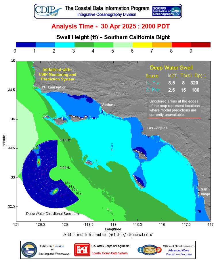
Southern California Swell Model
NOAA Santa Barbara County Southwestern Coast Surf Zone Forecast
Expires:202503290330;;308599
FZUS56 KLOX 281221
SRFLOX

Surf Zone Forecast
National Weather Service Los Angeles/Oxnard
521 AM PDT Fri Mar 28 2025


CAZ349-350-290330-
Santa Barbara County Southwestern Coast-
Santa Barbara County Southeastern Coast-
521 AM PDT Fri Mar 28 2025

...BEACH HAZARDS STATEMENT IN EFFECT UNTIL 11 AM PDT SATURDAY...
...HIGH RIP CURRENT RISK...

.TODAY...
Rip Current Risk*.............High.
Surf Height...................West Facing Beaches - 4 to 6 feet.
                              South Facing Beaches - 2 to 4 feet.
Thunderstorm Potential........None expected.
Water Temperature.............58 to 60 degrees.
Tides.........................Low 0.3 feet (MLLW) 04:21 AM PDT.
                              High 5.3 feet (MLLW) 10:28 AM PDT.
                              Low -0.3 feet (MLLW) 04:44 PM PDT.
                              High 5.3 feet (MLLW) 10:57 PM PDT.
Remarks.......................West swell.

.SATURDAY...
Rip Current Risk*.............High.
Surf Height...................West Facing Beaches - 4 to 6 feet, subsiding
                              to 3 to 5 feet by afternoon.
                              South Facing Beaches - 2 to 4 feet.
Thunderstorm Potential........None expected.
Tides.........................Low -0.2 feet (MLLW) 05:08 AM PDT.
                              High 5.0 feet (MLLW) 11:16 AM PDT.
                              Low 0.0 feet (MLLW) 05:15 PM PDT.
                              High 5.7 feet (MLLW) 11:28 PM PDT.
Remarks.......................West swell.


&&

Rip Current Risks:
* Low Risk - Life threatening rip currents are unlikely but still could occur.
* Moderate Risk - Life threatening rip currents are possible.
* High Risk - Life threatening rip currents are likely.

$$
Source: NOAA
East Santa Barbara Channel Coastal Waters Forecast (PZ 650)
Expires:202503290245;;313001
FZUS56 KLOX 281430
CWFLOX

Coastal Waters Forecast for California
National Weather Service Los Angeles/Oxnard CA
730 AM PDT Fri Mar 28 2025

Point Piedras Blancas to San Mateo Point CA out 60 NM including the
Channel Islands National Marine Sanctuary

...See weather.gov/marine/wavedetail for more info on the new Wave
Detail format...


PZZ650-290245-
East Santa Barbara Channel from Pt. Conception to Pt. Mugu CA
including Santa Cruz Island-
730 AM PDT Fri Mar 28 2025

...SMALL CRAFT ADVISORY IN EFFECT UNTIL 3 PM PDT THIS AFTERNOON...
...GALE WARNING IN EFFECT FROM 3 PM PDT THIS AFTERNOON THROUGH LATE
TONIGHT...

.TODAY...Western Portion, W wind 15 to 20 kt with gusts to 25 kt,
becoming 20 to 30 kt with gusts to 35 kt this afternoon. Eastern
Portion, W wind 5 to 10 kt, becoming 15 to 25 kt with gusts to
25 kt this afternoon. Seas 7 to 10 ft, building to 9 to 12 ft. Wave
Detail: W 10 ft at 10 seconds.
.TONIGHT...Western portion, W to NW wind 25 to 35 kt becoming 15 to
25 kt late. Eastern portion, W wind 20 to 30 kt becoming 10 to 20
kt after midnight. Seas 9 to 12 ft. Wave Detail: W 10 ft at 8
seconds.
.SAT...W to NW wind 10 to 20 kt, becoming 15 to 25 kt in the
afternoon. Seas 7 to 10 ft, subsiding to 6 to 8 ft. Wave Detail: W 9
ft at 11 seconds.
.SAT NIGHT...W wind 15 to 25 kt in the evening, becoming 10 to 15
kt. Seas 6 to 8 ft, subsiding to 4 to 6 ft. Wave Detail:
W 7 ft at 7 seconds.
.SUN...W wind 5 to 10 kt, becoming SE 5 to 10 kt in the afternoon.
Seas 3 to 5 ft, subsiding to 2 to 3 ft. Wave Detail: W 4 ft at 11
seconds. A slight chance of rain.
.SUN NIGHT...SE wind 10 to 15 kt in the evening, becoming 5 to 10 kt.
Seas 3 to 5 ft. Wave Detail: W 4 ft at 9 seconds and S 2 ft at 9
seconds. A slight chance of rain.
.MON...S wind 5 to 10 kt, becoming W 10 to 15 kt in the afternoon.
Seas 3 to 5 ft. Wave Detail: W 4 ft at 10 seconds.
.MON NIGHT...W wind 10 to 20 kt. Seas 3 to 5 ft. Wave Detail:
W 4 ft at 8 seconds.
.TUE...W to NW wind 10 to 20 kt, becoming 15 to 25 kt in the
afternoon. Seas 3 to 5 ft. Wave Detail: W 4 ft at 8 seconds.
.TUE NIGHT...W to NW wind 15 to 25 kt, becoming 10 to 20 kt after
midnight. Seas 3 to 5 ft. Wave Detail: W 4 ft at 7 seconds. A slight
chance of rain after midnight.

$$
Source: NOAA
Waters Forecast from Pt. Sal to Santa Cruz Island and Westward 60 NM (PZ 673)
Expires:202503290245;;312999
FZUS56 KLOX 281430
CWFLOX

Coastal Waters Forecast for California
National Weather Service Los Angeles/Oxnard CA
730 AM PDT Fri Mar 28 2025

Point Piedras Blancas to San Mateo Point CA out 60 NM including the
Channel Islands National Marine Sanctuary

...See weather.gov/marine/wavedetail for more info on the new Wave
Detail format...


PZZ673-290245-
Waters from Pt. Sal to Santa Cruz Island CA and westward 60 nm
including San Miguel and Santa Rosa Islands-
730 AM PDT Fri Mar 28 2025

...SMALL CRAFT ADVISORY IN EFFECT UNTIL 3 PM PDT THIS AFTERNOON...
...GALE WARNING IN EFFECT FROM 3 PM PDT THIS AFTERNOON THROUGH LATE
TONIGHT...

.TODAY...NW wind 15 to 20 kt with gusts to 25 kt, becoming 20 to
30 kt with gusts to 35 kt this afternoon. Seas 13 to 18 ft. Wave
Detail: S 3 ft at 14 seconds and W 18 ft at 15 seconds.
.TONIGHT...NW wind 25 to 35 kt, becoming 20 to 30 kt late. Seas 15
to 18 ft, subsiding to 12 to 15 ft late. Wave Detail: NW 17 ft at
14 seconds and S 2 ft at 18 seconds.
.SAT...NW wind 20 to 30 kt. Seas 12 to 14 ft, subsiding to 10 to 12
ft. Wave Detail: NW 13 ft at 13 seconds and S 2 ft at 17 seconds.
.SAT NIGHT...NW wind 15 to 25 kt, becoming 10 to 15 kt after
midnight. Seas 8 to 10 ft. Wave Detail: NW 10 ft at 12 seconds and S
2 ft at 17 seconds.
.SUN...NW wind 5 to 10 kt early, becoming S 10 to 20 kt. Seas 6 to
8 ft. Wave Detail: NW 7 ft at 11 seconds and S 4 ft at 14 seconds.
A chance of rain.
.SUN NIGHT...S wind 10 to 20 kt, becoming 5 to 10 kt after
midnight. Seas 5 to 7 ft. Wave Detail: W 7 ft at 10 seconds and SW 6
ft at 11 seconds. A slight chance of rain.
.MON...SW wind 5 to 10 kt, becoming W 10 to 15 kt in the afternoon.
Seas 6 to 7 ft. Wave Detail: W 7 ft at 10 seconds and S 3 ft at 14
seconds.
.MON NIGHT...NW wind 10 to 20 kt. Seas 5 to 6 ft. Wave Detail:
W 6 ft at 9 seconds and S 2 ft at 15 seconds.
.TUE...NW wind 15 to 25 kt. Seas 5 to 6 ft. Wave Detail: NW 6 ft at
9 seconds and S 2 ft at 15 seconds.
.TUE NIGHT...NW wind 20 to 30 kt. Seas 6 to 7 ft. Wave Detail: NW
7 ft at 9 seconds and S 2 ft at 16 seconds. A slight chance of rain
after midnight.

$$
Source: NOAA
Outer Waters Forecast from Santa Cruz Island to San Clemente Island to 60 NM Offshore (PZ 676)
Expires:202503290245;;313000
FZUS56 KLOX 281430
CWFLOX

Coastal Waters Forecast for California
National Weather Service Los Angeles/Oxnard CA
730 AM PDT Fri Mar 28 2025

Point Piedras Blancas to San Mateo Point CA out 60 NM including the
Channel Islands National Marine Sanctuary

...See weather.gov/marine/wavedetail for more info on the new Wave
Detail format...


PZZ676-290245-
Outer waters from Santa Cruz Island to San Clemente Island to 60 NM
offshore including San Nicolas and Santa Barbara Islands-
730 AM PDT Fri Mar 28 2025

...SMALL CRAFT ADVISORY IN EFFECT UNTIL 3 PM PDT THIS AFTERNOON...
...GALE WARNING IN EFFECT FROM 3 PM PDT THIS AFTERNOON THROUGH LATE
TONIGHT...

.TODAY...NW wind 15 to 20 kt with gusts to 25 kt, becoming
20 to 30 kt with gusts to 35 kt this afternoon. Seas 12 to 16 ft,
subsiding to 11 to 14 ft. Wave Detail: S 2 ft at 14 seconds and
W 14 ft at 15 seconds.
.TONIGHT...NW wind 25 to 35 kt, becoming 20 to 30 kt late. Seas 13
to 16 ft. Wave Detail: NW 15 ft at 9 seconds and S 2 ft at 18
seconds.
.SAT...NW wind 20 to 30 kt. Seas 12 to 15 ft, subsiding to 10 to 12
ft. Wave Detail: NW 14 ft at 11 seconds and S 2 ft at 17 seconds.
.SAT NIGHT...NW wind 15 to 25 kt, becoming 10 to 15 kt after
midnight. Seas 7 to 10 ft. Wave Detail: NW 10 ft at 11 seconds and S
2 ft at 17 seconds.
.SUN...W wind 10 to 15 kt, becoming S 10 to 15 kt in the afternoon.
Seas 6 to 8 ft. Wave Detail: NW 7 ft at 11 seconds and S 2 ft at 16
seconds. A chance of rain.
.SUN NIGHT...S wind 10 to 15 kt, becoming 5 to 10 kt late. Seas 4
to 6 ft. Wave Detail: W 5 ft at 10 seconds and SW 3 ft at 14
seconds. A slight chance of rain.
.MON...S wind 5 to 10 kt, becoming W 10 to 15 kt in the afternoon.
Seas 5 to 7 ft. Wave Detail: W 6 ft at 10 seconds and S 3 ft at 14
seconds. A slight chance of rain in the morning.
.MON NIGHT...NW wind 10 to 20 kt. Seas 5 to 6 ft. Wave Detail:
W 5 ft at 9 seconds and S 2 ft at 15 seconds.
.TUE...NW wind 15 to 25 kt. Seas 4 to 6 ft. Wave Detail: NW 5 ft at
8 seconds and S 2 ft at 15 seconds.
.TUE NIGHT...NW wind 30 to 30 kt. Seas 5 to 6 ft. Wave Detail:
NW 6 ft at 7 seconds and S 2 ft at 16 seconds.

$$
Source: NOAA
Inner Waters Forecast from Pt. Mugu to San Mateo Pt. (PZ 655)
Expires:202503290245;;313002
FZUS56 KLOX 281430
CWFLOX

Coastal Waters Forecast for California
National Weather Service Los Angeles/Oxnard CA
730 AM PDT Fri Mar 28 2025

Point Piedras Blancas to San Mateo Point CA out 60 NM including the
Channel Islands National Marine Sanctuary

...See weather.gov/marine/wavedetail for more info on the new Wave
Detail format...


PZZ655-290245-
Inner waters from Point Mugu to San Mateo Pt. CA including Santa
Catalina and Anacapa Islands-
730 AM PDT Fri Mar 28 2025

...SMALL CRAFT ADVISORY IN EFFECT THROUGH SATURDAY EVENING...

.TODAY...W wind 10 to 15 kt, becoming 15 to 25 kt with gusts to
30 kt this afternoon. Strongest western portion. Seas 6 to 8 ft,
building to 7 to 10 ft. Wave Detail: W 9 ft at 11 seconds. A slight
chance of rain with patchy drizzle this morning. Patchy fog this
morning.
.TONIGHT...Northwestern portion, W to NW wind 20 to 30 kt with local
gusts to 35 kt becoming 15 to 25 kt late. Elsewhere, W wind 15 to
25 kt becoming 10 to 20 kt after midnight. Seas 7 to 10 ft. Wave
Detail: W 10 ft at 8 seconds.
.SAT...W to NW wind 10 to 20 kt, becoming 15 to 25 kt in the
afternoon. Seas 6 to 9 ft. Wave Detail: W 8 ft at 9 seconds and SW
2 ft at 17 seconds.
.SAT NIGHT...W to NW wind 15 to 25 kt in the evening, becoming 10
to 15 kt. Seas 5 to 7 ft. Wave Detail: W 6 ft at 8 seconds and S 2
ft at 17 seconds.
.SUN...W wind 10 to 15 kt, becoming S 5 to 10 kt in the afternoon.
Seas 4 to 6 ft, subsiding to 3 to 4 ft. Wave Detail: W 5 ft at 7
seconds and S 2 ft at 16 seconds.
.SUN NIGHT...SE to S wind 10 to 15 kt. Seas 2 to 4 ft. Wave Detail:
W 3 ft at 9 seconds and SW 3 ft at 12 seconds.
.MON...S wind 10 to 15 kt, becoming W 10 to 15 kt in the afternoon.
Seas 3 to 4 ft. Wave Detail: W 4 ft at 10 seconds and SW 2 ft at 15
seconds.
.MON NIGHT...W wind 10 to 20 kt. Seas 3 to 5 ft. Wave Detail:
W 4 ft at 9 seconds and S 2 ft at 15 seconds.
.TUE...W to NW wind 10 to 20 kt, becoming 15 to 25 kt in the
afternoon. Seas 3 to 5 ft. Wave Detail: W 4 ft at 8 seconds and S 2
ft at 15 seconds.
.TUE NIGHT...W to NW wind 15 to 25 kt, becoming 10 to 20 kt after
midnight. Seas 3 to 5 ft. Wave Detail: W 4 ft at 6 seconds.

$$

RAT

www.weather.gov/losangeles
Source: NOAA
Site Navigation
©1999-2025 by Steve Lange
All swell and tide information above copyright their respective owners